
Web Mercator vs True Size: Global Distortion Animation
🌍 Web Mercator vs True Size: Global Distortion Animation
Visualizing the Real Scale of Nations with Python
Can you spot the real size of Greenland from this visualization?
 (Above: The animated transition from Web Mercator distortion to True Size)
📝 Overview
This project visualizes the dramatic spatial distortions inherent in the Web Mercator projection (used by Google Maps, Bing, etc.) by animating countries transitioning to their true relative sizes. While the Mercator projection is excellent for navigation, it severely exaggerates the size of landmasses near the poles.
Using Python and Geopandas, this tool calculates the area distortion ratio for every country and generates a frame-by-frame animation where high-latitude nations (like Russia and Canada) "deflate" to their actual proportions, while equatorial regions remain stable. The result is a "Cyberpunk-styled" timelapse that corrects our mental map of the world.
🎯 Objectives
- Objective 1: Quantify and visualize the area distortion of the Web Mercator projection compared to an Equal-Area projection (Mollweide).
- Objective 2: Develop a Python algorithm to smoothly scale polygon geometries relative to their centroids without shifting their geographic position.
- Objective 3: Promote geographical literacy by debunking common misconceptions, such as Greenland appearing as large as Africa.
🛠️ Tools & Technologies
⚙️ Methodology
| Step | Description |
|---|---|
| 1. Data Collection | Loaded global administrative boundaries (ne_110m_admin_0_countries) from Natural Earth using Geopandas. |
| 2. Projection Math | Reprojected geometry to Web Mercator (EPSG:3857) for the "distorted" view and Mollweide (Equal Area) for the "true" view to calculate area ratios. |
| 3. Scale Calculation | Defined the scaling factor for each country as $1 / \sqrt{\text{Distortion Ratio}}$ to normalize areas while maintaining shape. |
| 4. Animation Logic | Implemented a loop to interpolate the scale factor from 1.0 (Mercator) to final_scale (True Size), locking transformations to each polygon's centroid. |
| 5. Visualization | Rendered 30+ frames with a Neon Cyberpunk color palette and compiled them into a GIF using imageio. |
Imports
import os
import numpy as np
import geopandas as gpd
import matplotlib.pyplot as plt
from shapely.affinity import scale
from shapely.geometry import MultiPolygon, Point
from shapely.ops import transform
from pyproj import Transformer
import os
import imageio.v3 as iio
import random
from IPython.display import HTML, display

# inspo: https://www.openculture.com/2019/04/animated-maps-animated-maps-reveal-the-true-size-of-countries-the-true-size-of-countries.html#google_vignette
1. Compute distortion factors
world = gpd.read_file("Data/ne_110m_admin_0_countries/ne_110m_admin_0_countries.shp")
world = world[world.ADMIN != "Antarctica"]

# Distorted (Web Mercator)
world = world.to_crs(3857)

# True area (Equal Earth)
moll = "+proj=moll +lon_0=0 +a=6378137 +b=6356752.314245179 +units=m +no_defs"
world_eq = world.to_crs(moll)


# Compute areas
world["area_m2"] = world.geometry.area              # distorted area
world_eq["area_eq_m2"] = world_eq.geometry.area     # true area
world["area_eq_m2"] = world_eq["area_eq_m2"]

world.crs
<Projected CRS: EPSG:3857>
Name: WGS 84 / Pseudo-Mercator
Axis Info [cartesian]:
- X[east]: Easting (metre)
- Y[north]: Northing (metre)
Area of Use:
- name: World between 85.06°S and 85.06°N.
- bounds: (-180.0, -85.06, 180.0, 85.06)
Coordinate Operation:
- name: Popular Visualisation Pseudo-Mercator
- method: Popular Visualisation Pseudo Mercator
Datum: World Geodetic System 1984 ensemble
- Ellipsoid: WGS 84
- Prime Meridian: Greenwich
# Compute distortion ratio: distorted / true
world["distortion_ratio"] = world["area_m2"] / world["area_eq_m2"]

world[world["distortion_ratio"]>1].sort_values(by = "distortion_ratio", ascending = False)[["ADMIN", "distortion_ratio"]]
| ADMIN | distortion_ratio | |
|---|---|---|
| 22 | Greenland | 16.533132 |
| 21 | Norway | 9.379780 |
| 144 | Iceland | 5.635242 |
| 151 | Finland | 5.464241 |
| 3 | Canada | 5.218689 |
| ... | ... | ... |
| 169 | Rwanda | 1.001327 |
| 44 | Ecuador | 1.001169 |
| 168 | Uganda | 1.001133 |
| 69 | Equatorial Guinea | 1.000908 |
| 68 | Gabon | 1.000697 |
176 rows × 2 columns
world.plot()
world_eq.plot()
world.plot(column = "distortion_ratio", cmap = "RdYlGn")
<Axes: >


2. Draw the re-scaled map
scaled_geoms = []

for idx, row in world.iterrows():

    geom = row.geometry
    ratio = row["distortion_ratio"]

    factor = 1.0 / np.sqrt(row["distortion_ratio"])
    cx, cy = geom.centroid.x, geom.centroid.y


    scaled = scale(
        geom,
        xfact=factor,
        yfact=factor,
        origin=(cx, cy)
    )

    scaled_geoms.append(scaled)


world_scaled = world.copy()
world_scaled["geometry"] = scaled_geoms
world_scaled.plot()
<Axes: >

minx, miny, maxx, maxy = world.total_bounds

fig, ax = plt.subplots(1, 1, figsize=(7, 7))

world.plot(ax=ax, edgecolor="k", color = "skyblue", linewidth=0.3)
world_scaled.plot(ax=ax, edgecolor="black", linewidth=0.3)

ax.set_xlim(minx, maxx)
ax.set_ylim(miny, maxy)

ax.text(0.01, 1.15, "Web Mercator Projection vs True Size", transform=ax.transAxes,
        fontsize=20, fontweight="bold", va="top")


ax.axis("off")
plt.tight_layout()
plt.show()

3. Create an animation
# Load the file with standard quotes
world = gpd.read_file("Data/ne_110m_admin_0_countries/ne_110m_admin_0_countries.shp")

# Filter out Antarctica
world = world[world.ADMIN != 'Antarctica']

# Distorted (Web Mercator)
world = world.to_crs(3857)
world["area_m2"] = world.area

# Equal-area baseline (Mollweide, spherical Earth)
moll = "+proj=moll +lon_0=0 +R=6371000 +units=m +no_defs"
world_moll = world.to_crs(moll)
world["area_moll_m2"] = world_moll.area

# Area distortion ratio
world["distortion_ratio"] = world["area_m2"] / world["area_moll_m2"]

# Precompute final linear scale factor per country (for t = 1)
# Note: Ensure you have run 'import numpy as np' before this line
world["final_scale"] = 1.0 / np.sqrt(world["distortion_ratio"])

# Global bounds from original world
minx, miny, maxx, maxy = world.total_bounds
n_frames = 30
foldout = 'frames' # Fixed the smart quotes here
os.makedirs(foldout, exist_ok=True)
for step in range(n_frames + 1):
    t = step / n_frames  # goes 0 → 1

    scaled_geoms = []

    for idx, row in world.iterrows():
        geom = row.geometry
        final_factor = row["final_scale"] # Fixed quotes

        # interpolate between 1.0 (Mercator) and final_factor (True Size)
        factor_t = 1.0 + t * (final_factor - 1.0)

        # centroid for anchoring the transformation
        cx, cy = geom.centroid.x, geom.centroid.y

        scaled = scale(
            geom,
            xfact=factor_t,
            yfact=factor_t,
            origin=(cx, cy)
        )
        scaled_geoms.append(scaled)

    # build a temporary GeoDataFrame for this frame
    world_frame = world.copy()
    world_frame["geometry"] = scaled_geoms # Fixed quotes

    # plot
    fig, ax = plt.subplots(1, 1, figsize=(10, 10))

    # optional: show original outline faintly for reference
    world.plot(ax=ax, edgecolor="k", facecolor="skyblue", linewidth=0.3) # Fixed quotes
    world_frame.plot(ax=ax, edgecolor="black", color="steelblue", linewidth=0.3) # Fixed quotes

    ax.text(0.01, 1.21, "Web Mercator Projection vs True Size", transform=ax.transAxes,
            fontsize=20, fontweight="bold", va="top") # Fixed quotes

    ax.set_xlim(minx, maxx)
    ax.set_ylim(miny, maxy)
    ax.axis("off") # Fixed quotes

    plt.tight_layout()
    # Fixed quotes and path separator
    plt.savefig(f"{foldout}/frame_{step:03d}.png", dpi=200)
    plt.close(fig)

    # Progress indicator
    if step % 5 == 0:
        print(f"Finished frame {step}/{n_frames}")
Finished frame 0/30
Finished frame 5/30
Finished frame 10/30
Finished frame 15/30
Finished frame 20/30
Finished frame 25/30
Finished frame 30/30
# Save as GIF
output_gif = "projection_timelapse.gif"
iio.imwrite(output_gif, images, duration=100, loop=0) # duration is ms per frame

print(f"Saved GIF to {output_gif}")
display(HTML(f'<img src="{output_gif}" width="500" />'))
Saved GIF to projection_timelapse.gif

4. Design upgrade
# Load the images you just created ---
import os
import imageio.v3 as iio

foldout = 'frames'
files = sorted([f for f in os.listdir(foldout) if f.endswith(".png")])
images = [iio.imread(os.path.join(foldout, f)) for f in files]
# -------------------------------------------------------

# Now this will work:
output_gif = "projection_timelapse.gif"
iio.imwrite(output_gif, images, duration=100, loop=0)
print(f"Saved GIF to {output_gif}")
Saved GIF to projection_timelapse.gif
import geopandas as gpd
import matplotlib.pyplot as plt
from shapely.affinity import scale
import numpy as np
import os
import imageio.v3 as iio
from IPython.display import Image, display

# Settings
foldout = "frames_neon"
output_gif = "projection_timelapse_neon.gif"
n_frames = 30
n_cycles = 1 # How many times to repeat the pulse in the GIF
os.makedirs(foldout, exist_ok=True)

# 1. LOAD DATA
# Note: Using the path from your code.
# If this fails, revert to "zip://ne_10m_admin_0_countries.zip"
try:
    world = gpd.read_file("Data/ne_110m_admin_0_countries/ne_110m_admin_0_countries.shp")
except:
    world = gpd.read_file("zip://ne_10m_admin_0_countries.zip")

world = world[world.ADMIN != "Antarctica"]

# 2. CALCULATE DISTORTION
world = world.to_crs(3857) # Mercator
world["area_m2"] = world.geometry.area

moll = "+proj=moll +lon_0=0 +R=6371000 +units=m +no_defs" # Mollweide
world_moll = world.to_crs(moll)
world["area_moll_m2"] = world_moll.geometry.area

world["distortion_ratio"] = world["area_m2"] / world["area_moll_m2"]
world["final_scale"] = 1.0 / np.sqrt(world["distortion_ratio"])

# 3. NEON COLORS SETUP
# ============================================
# 3. COLORS: CYBERPUNK / VAPORWAVE PALETTE
# ============================================
continent_colors = {
    "Africa":        "#FF00CC",  # Hot Magenta
    "Europe":        "#00F0FF",  # Electric Cyan
    "Asia":          "#BD00FF",  # Deep Neon Violet
    "North America": "#FF1493",  # Deep Pink
    "South America": "#E056FD",  # Soft Orchid/Light Purple
    "Oceania":       "#4DEEEA",  # Neon Turquoise
    "Seven seas (open ocean)": "#4DEEEA"
}

# Map colors...
world["neon_color"] = world["CONTINENT"].map(continent_colors).fillna("white")
# Map colors, default to white if continent not found
world["neon_color"] = world["CONTINENT"].map(continent_colors).fillna("white")
minx, miny, maxx, maxy = world.total_bounds

# 4. GENERATE FRAMES (Pulsing Loop)
# This creates a list that goes 0 -> 30 -> 0
cycle_indices = list(range(n_frames + 1)) + list(range(n_frames - 1, -1, -1))
print(f"Generating {len(cycle_indices)} frames...")

for frame_id, step in enumerate(cycle_indices):
    t = step / n_frames

    scaled_geoms = []
    for idx, row in world.iterrows():
        geom = row.geometry
        f_final = row["final_scale"]

        # Interpolate scale
        f_t = 1.0 + t * (f_final - 1.0)

        cx, cy = geom.centroid.x, geom.centroid.y
        scaled_geoms.append(scale(geom, xfact=f_t, yfact=f_t, origin=(cx, cy)))

    world_frame = world.copy()
    world_frame["geometry"] = scaled_geoms

    # Dark Mode Plot
    fig, ax = plt.subplots(figsize=(16, 9))
    fig.patch.set_facecolor("black")
    ax.set_facecolor("black")

    world_frame.plot(
        ax=ax,
        color=world_frame["neon_color"],
        edgecolor="black",
        linewidth=0.2,
        alpha=0.9
    )

    ax.text(
        0.5, 1.02,
        "Web Mercator vs True Size",
        transform=ax.transAxes,
        fontsize=20,
        fontweight="bold",
        color="white",
        ha="center",
        va="bottom"
    )

    ax.set_xlim(minx, maxx)
    ax.set_ylim(miny, maxy)
    ax.axis("off")

    plt.tight_layout()
    plt.savefig(f"{foldout}/frame_{frame_id:03d}.png", dpi=100, bbox_inches='tight', facecolor="black")
    plt.close(fig)

    if frame_id % 10 == 0:
        print(f"Rendered frame {frame_id}/{len(cycle_indices)}")

# 5. COMPILE GIF
print("Compiling GIF...")
files = sorted([f for f in os.listdir(foldout) if f.endswith(".png")])
images = [iio.imread(os.path.join(foldout, f)) for f in files]
iio.imwrite(output_gif, images, duration=50, loop=0)

print(f"Done! Displaying {output_gif}")
display(Image(filename=output_gif))
Generating 61 frames...
Rendered frame 0/61
Rendered frame 10/61
Rendered frame 20/61
Rendered frame 30/61
Rendered frame 40/61
Rendered frame 50/61
Rendered frame 60/61
Compiling GIF...
Done! Displaying projection_timelapse_neon.gif
<IPython.core.display.Image object>
import geopandas as gpd
import matplotlib.pyplot as plt
from shapely.affinity import scale
import numpy as np
import os
import imageio.v3 as iio
from IPython.display import Image, display
# ============================================
# 1. SETTINGS
# ============================================
foldout = "frames_white_blue"
output_gif = "projection_timelapse_white_blue.gif"
n_frames = 30 # Frames per expansion cycle
os.makedirs(foldout, exist_ok=True)
print("--- Step 1: Loading Data ---")
# ============================================
# 2. LOAD DATA
# ============================================
try:
world = gpd.read_file("Data/ne_110m_admin_0_countries/ne_110m_admin_0_countries.shp")
print("Loaded local shapefile.")
except:
print("Local file not found, downloading from Natural Earth...")
world = gpd.read_file("zip://ne_10m_admin_0_countries.zip")
world = world[world.ADMIN != "Antarctica"]
# ============================================
# 3. CALCULATE DISTORTION
# ============================================
print("--- Step 2: Calculating Projections ---")
# Mercator (Distorted)
world = world.to_crs(3857)
world["area_m2"] = world.geometry.area
# Mollweide (True Size)
moll = "+proj=moll +lon_0=0 +R=6371000 +units=m +no_defs"
world_moll = world.to_crs(moll)
world["area_moll_m2"] = world_moll.geometry.area
# Calculate Ratio and Scale Factor
world["distortion_ratio"] = world["area_m2"] / world["area_moll_m2"]
world["final_scale"] = 1.0 / np.sqrt(world["distortion_ratio"])
# ============================================
# 4. DEFINE STYLE (WHITE/BLUE)
# ============================================
# A single slate-blue color similar to the reference image
slate_blue = "#4a8bad"
world["style_color"] = slate_blue
bg_color = "#FFFFFF" # Pure White Background
border_color = "#000000" # White borders
text_color = "#000000" # Black text
minx, miny, maxx, maxy = world.total_bounds
# ============================================
# 5. GENERATE ANIMATION FRAMES
# ============================================
print(f"--- Step 3: Generating Frames in '{foldout}/' ---")
# Cycle: Small -> Big -> Small
cycle_indices = list(range(n_frames + 1)) + list(range(n_frames - 1, -1, -1))
for frame_id, step in enumerate(cycle_indices):
t = step / n_frames
scaled_geoms = []
for idx, row in world.iterrows():
geom = row.geometry
f_final = row["final_scale"]
# Interpolate scale
f_t = 1.0 + t * (f_final - 1.0)
# Lock to centroid
cx, cy = geom.centroid.x, geom.centroid.y
scaled_geoms.append(scale(geom, xfact=f_t, yfact=f_t, origin=(cx, cy)))
world_frame = world.copy()
world_frame["geometry"] = scaled_geoms
# --- PLOTTING ---
fig, ax = plt.subplots(figsize=(10, 10))
# Set White Background
fig.patch.set_facecolor(bg_color)
ax.set_facecolor(bg_color)
world_frame.plot(
ax=ax,
color=world_frame["style_color"], # Use the single slate blue
edgecolor=border_color, # White borders
linewidth=0.4,
alpha=1.0 # Solid fill (no transparency)
)
# Title
ax.text(
0.5, 1.02,
"World Mercator projection vs True Size",
transform=ax.transAxes,
fontsize=20,
color=text_color, # Black text
ha="center",
weight = "bold",
va="bottom"
)
# Credit (optional, matches image style)
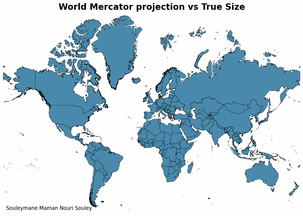
ax.text(
0.01, 0.01,
"Souleymane Maman Nouri Souley",
transform=ax.transAxes,
fontsize=12,
color=text_color,
ha="left",
va="bottom"
)
ax.set_xlim(minx, maxx)
ax.set_ylim(miny, maxy)
ax.axis("off")
plt.tight_layout()
# Save Frame with white background
filename = f"{foldout}/frame_{frame_id:03d}.png"
plt.savefig(filename, dpi=100, facecolor=bg_color, bbox_inches='tight')
plt.close(fig)
if frame_id % 10 == 0:
print(f"Rendered frame {frame_id}/{len(cycle_indices)}")
# ============================================
# 6. COMPILE GIF
# ============================================
print("--- Step 4: Compiling GIF ---")
files = sorted([f for f in os.listdir(foldout) if f.endswith(".png")])
images = [iio.imread(os.path.join(foldout, f)) for f in files]
# duration=50ms is approx 20fps
iio.imwrite(output_gif, images, duration=50, loop=0)
print(f"Done! Saved as: {output_gif}")
# ============================================
# 7. DISPLAY
# ============================================
display(Image(filename=output_gif))
--- Step 1: Loading Data ---
Loaded local shapefile.
--- Step 2: Calculating Projections ---
--- Step 3: Generating Frames in 'frames_white_blue/' ---
Rendered frame 0/61
Rendered frame 10/61
Rendered frame 20/61
Rendered frame 30/61
Rendered frame 40/61
Rendered frame 50/61
Rendered frame 60/61
--- Step 4: Compiling GIF ---
Done! Saved as: projection_timelapse_white_blue.gif
<IPython.core.display.Image object>
📊 Results & Insights
The animation reveals the stark reality of our world map:
- 🌍 The Greenland Myth: Greenland shrinks dramatically, revealing it is roughly the size of the Democratic Republic of the Congo, not the size of Africa.
- 📈 High-Latitude Inflation: Russia, Canada, and Scandinavia appear 2-4x larger on standard maps than they are in reality.
- 🧭 Equatorial Stability: Countries near the equator (e.g., Brazil, Indonesia) undergo almost no change, highlighting where Mercator is most accurate.
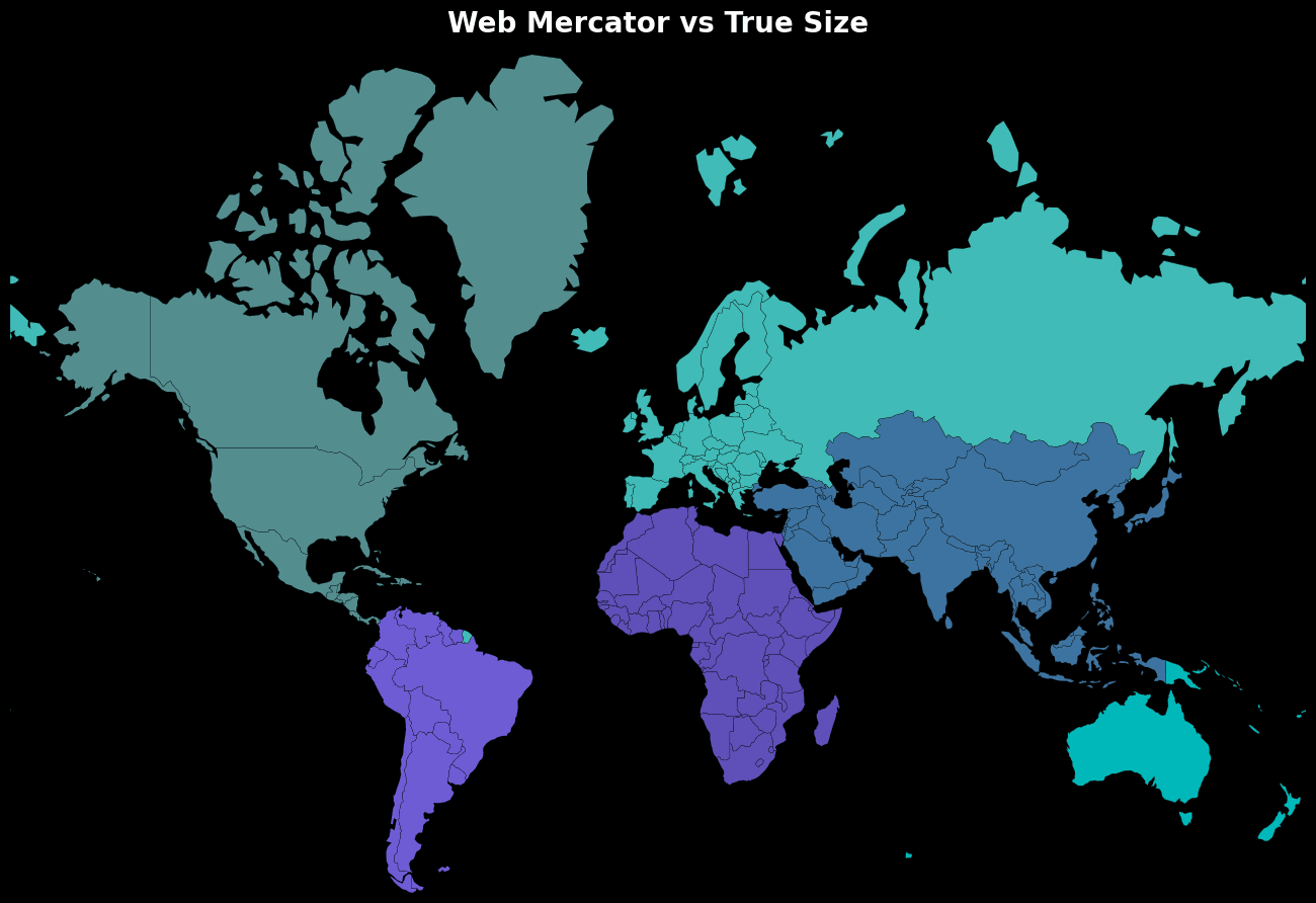
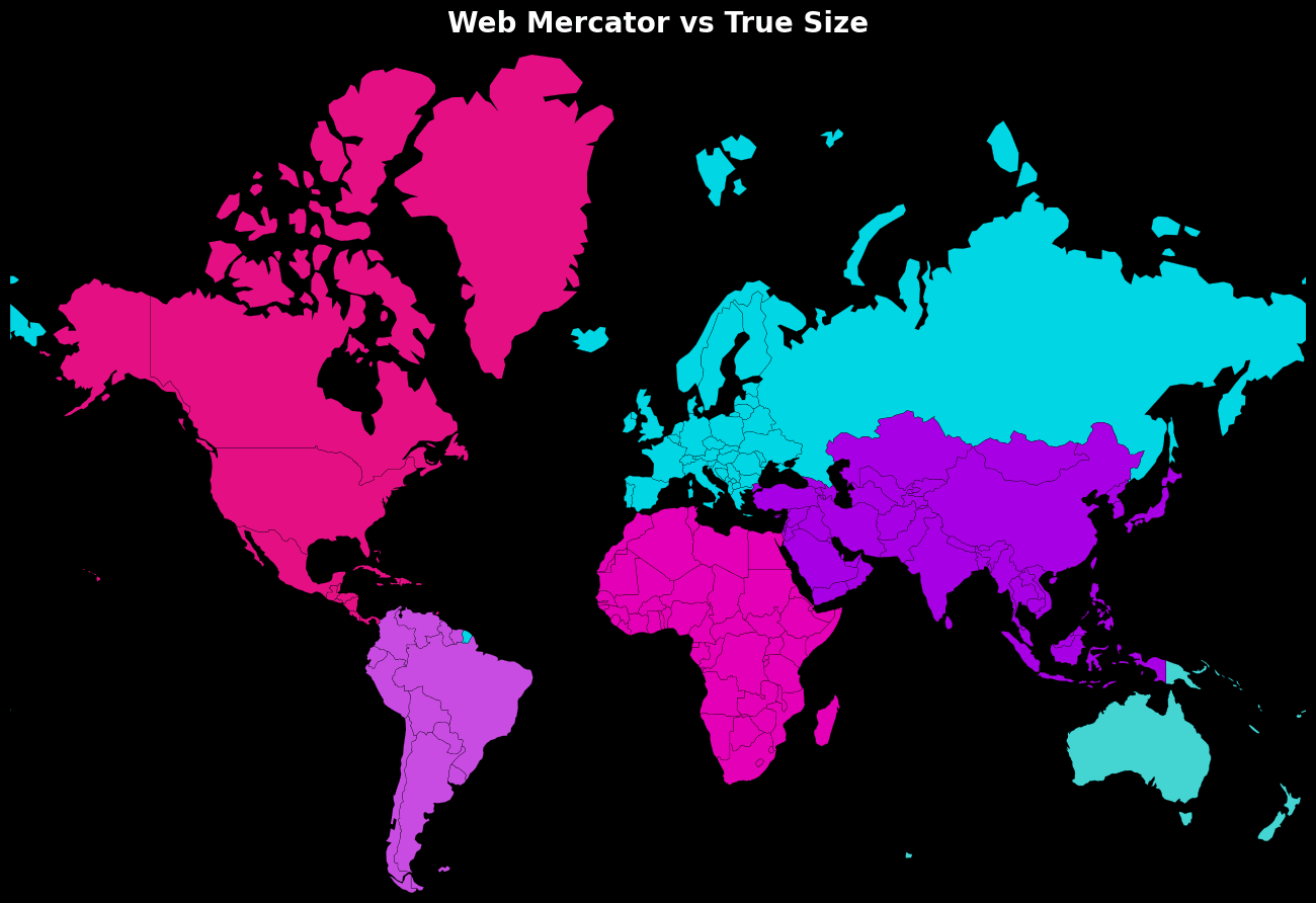 Caption: The "pulsing" animation cycle showing countries shrinking to their true size.
🗂️ Data Sources
| Source | Description | Link |
|---|---|---|
| Natural Earth | Admin 0 - Countries (1:110m) Shapefile | Natural Earth Data |
🔖 Tags
GIS Python Cartography Data Visualization Geopandas Mercator Projection Spatial Analysis True Size
📌 Credits & Acknowledgments
- 👨💻 Author: Souleymane Maman Nouri Souley
- 🙌 Inspiration: Inspired by the work of Milan Janosov and Imtiaj Iqbal Mahfuj on same topic.
- 🗂️ Data Sources: Natural Earth